
The Hydrography and Tidal Affairs Department announces:
International Publication of 2 New Kangan Port Navigational Charts
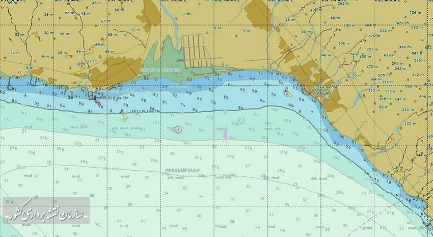
Announcing the international publication of Kangan port charts and Kangan port access to Deir, the Hydrographic and Tidal Affairs Department of the National Cartographic Center of IRAN announced the possibility of sailors using these charts for safe navigation in the country's waters. With the publication of these charts, the number of charts that the NCC has internationally published reaches 65.
Announcing the international release of Kangan port charts and its access to Deir, the hydrography and tidal affairs department of the National Cartographic Center of IRAN reported the possibility of sailors using these charts for safe navigation in the country's waters and also announced the number of published charts reached 65 Navigational Charts at the international level.
According to the NCC, Atieh Mojtahedi, deputy manager of hydrography and tidal affairs of the NCC, announced the global release of the Kangan port Navigational Charts and Kangan access chart to Daier, and added "The electronic navigational charts have been internationally published and made available to sailors after final controls under the standards of the World Hydrographic Organization. The port chart is in the scale of 1: 10000 and the chart of Kangan access to Daier is in the scale of 1:40000." With the publication of these two charts from Kangan port, the land use of this area from the port to the coast will be completed."
She added: "The international release of Navigational Charts has started since 2015, and the number of coastal land use charts from the country's waters reaches 18, access charts reaches 42 and port charts sometimes reaches 5.
"By the release of internal charts, while ensuring maritime safety in inland waters and under the sovereignty of the country, old charts prepared by foreign countries (Britain and Russia) are removed and updated charts of the Islamic Republic of Iran are replaced."
“Vessels are required to use up-to-date charts in order to maintain maritime safety and in accordance with international law," she said. "Navigational Charts are now available in electronic format (ENC), which is a requirement of navigation."
These charts are also monitored by authorities under the auspices of the World Hydrographic Organization (IHO) prior to publication and are allowed to be published after verification. "The new charts, which were prepared in the access and port user band, have been updated this year, and after making the necessary controls and corrections, permission issued and now has been published."
Mojtahedi pointed out: "Considering the importance of maritime trade and the realization of a maritime economy, hydrography, production and publication of inland waters charts under the rule of the Islamic Republic of Iran are among the priorities of the NCC and the national hydrographic committee"


comment