
The Hydrography and Tidal Affairs Department announces:
International Publication of First Berthing Chart
Shahid Rajaee Port Berthing Chart was internationally published.
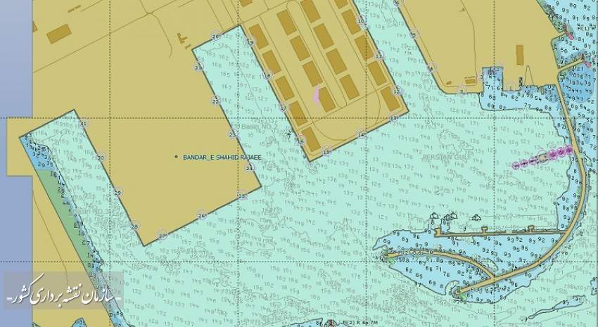
According to the NCC news, The Hydrography and Tidal Affairs Department of the National Cartographic Center of IRAN announced the international publication of the first berthing chart of the country’s largest commercial port (Shahid Rajaei), and the possibility of sailors using this chart for safe and accurate navigation in Shahid Rajaei Port and added the number of charts published internationally reached 63 navigational charts.
Atieh Mojtahedi, deputy manager of Hydrography and Tidal Affairs Department of the National Cartographic Center, announced with the production of this chart, the coastal landing strip to the berthing of this port will be completed and provided to sailors.
Shahid Rajaei port has a major role in the commercial development of the country and the preparation and updating of its navigational charts always have a special place for the NCC. Due to the importance of this issue, the chain of Shahid Rajaei port navigational charts was completed according to the standards of the International Hydrographic Organization (IHO).
She added: "Since 2015, NCC with nearly four decades of hydrographic experiences has published a marine chart" and necessary arrangements are made by the National Hydrographic Committee to prioritize and publish maritime charts. International navigation charts must be prepared in accordance with the latest standards of the World Hydrographic Organization and are constantly updated. These charts are also monitored by authorities under the auspices of the World Hydrographic Organization (IHO) prior to publication and are allowed to be published after verification.
In the end, she said: "The berthing navigation chart of Shahid Rajaei port is the largest scale chart of this important commercial port, which is used to help accurate navigation, so has the highest accuracy, especially in the field of coastal features."
The Shahid Rajaee Port Special Economic Zone is located 23 km west of Bandar Abbas, north of Qeshm Island and the Hormuz Strait, and having maritime relations and trade with 80 famous international ports, almost half of Iran's trade takes place over there.


comment