
Hydrography and Tidal Affairs Department announced:
International publishing of Astara port navigation chart
With international publishing of the chart of access to Astara port, it becomes possible for sailors to use this chart for safe navigation in the country's waters. It should be noted that with publishing of this chart, the total number of charts published by National Cartographic Center of Iran (NCC) at the international level reached 61 marine navigation charts, 13 of which belong to the Caspian Sea and the rest belong to the Persian Gulf and the Sea of Oman.
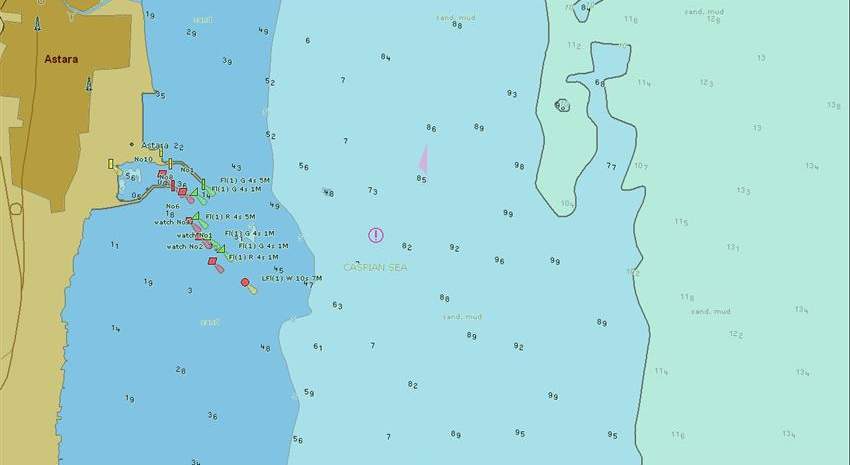
According to NCC report, Hydrography and Tidal Affairs Department of National Cartographic Center of Iran announced the international publishing of the chart of access to Astara port, while stating that it is now possible for sailors to use this chart for safe navigation in the country's waters.
Ms. Mojtahedi, Deputy of Hydrography and Tidal Affairs Department of NCC, explained that: “This chart is on a scale of 1: 25000, which is classified as the approach usage band according to the standards of International Hydrographic Organization (IHO). The coverage of this chart is up to 13 km away from Astara port in the depth of the sea, and regarding its recent publishing in the coastal usage band, at present both approach and coastal usage bands of Astara port have been completed”.
While stating that Hydrography and Tidal Affairs Department of National Cartographic Center of Iran with more than three decades of experience in the field of hydrography is responsible for preparing marine charts from the southern and northern waters of the country, she added “Vessels are required to use up-to-date marine navigation charts in accordance with international law to maintain maritime safety. Marine charts are now available in electronic format (ENC), which is a maritime requirement”.
According to Hydrography and Tidal Affairs Department, the necessary arrangements are done by the National Hydrographic Committee to prioritize and publish marine charts, and maritime navigation charts will be published by the committee according to its priorities. Maritime navigation charts must be prepared in accordance with the latest standards of International Hydrographic Organization (IHO) in order to be published internationally. These charts must be updated constantly. The new published chart, which is prepared at the approach usage band, has been updated in 2020. The permission for its publication is issued by IHO authorities, after necessary controls and corrections.
Mojtahedi pointed out: “The Caspian Sea is of great importance in the field of maritime trade between the Islamic Republic of Iran and its peripheral countries, and therefore, preparing and publishing a chart of the southern part of the sea under the rule of the Islamic Republic of Iran has been one of the priorities of NCC and the National Hydrographic Committee for the past three years. Other charts are being prepared from the shores of the Caspian Sea, which will be published in the near future”.


comment