
Following the quick reaction of the crisis management units of National Cartographic Center of Iran:
Production of maps from population centers with the highest possibility of snowfall and flooding based on proximity to steep slopes and rivers was done by National Cartographic Center of Iran (NCC)
Following the latest rain and snow warning for the southwest regions of Iran during 28 to 30 December 2020, from National Disaster Management Organization of Iran, the Technical Deputy of NCC called the specialized committee of flood, under supervision of its Crisis Management Commission, and this committee took immediate action by using advanced spatial technologies and identified population centers with the highest possibility of flooding based on proximity to steep slopes and rivers on the maps. NCC reported the results to National Disaster Management Organization officials and sent the flood warning maps as a precaution to the officials of five in risk provinces on 27, December 2020.
According to NCC report, all the produced maps, which show the location of flood risk as a warning, are available through NCC geoportal to the address https://iransdi.ir/layersf/disaster. These maps are available to all the officials of Disaster Management Organization of Iran, rescue and relief groups, executive bodies and the public.

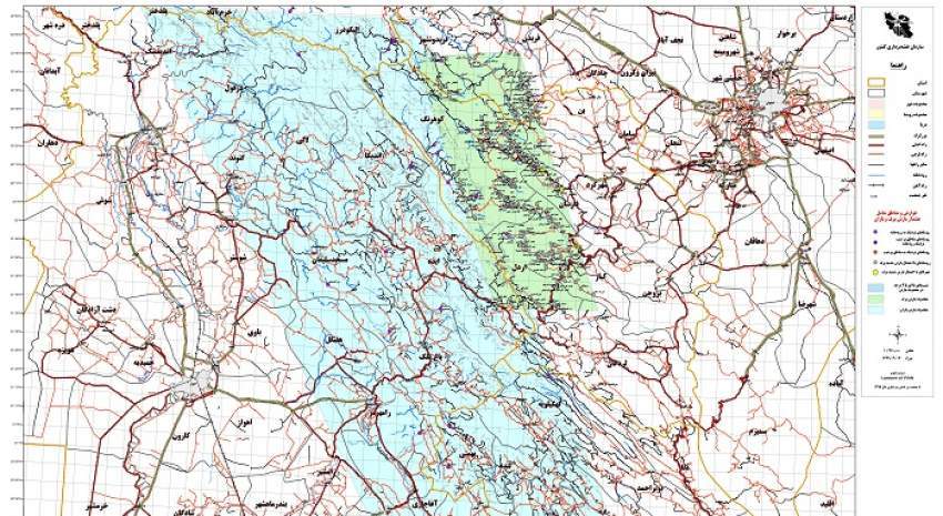
In the picture above, which shows a part of NCC geoportal, cities with snowfall prediction are marked with a white circle and villages along rivers are marked with a blue circle.
It is worth mentioning that during the last week and for the first time in NCC, similar to this rapid action (identifying population centers with the highest possibility of flooding) was done, based on meteorological warnings and the results were considered useful after verification by the crisis management colleagues, while appropriate preventive measures were taken based on these maps.
NCC created a new structure of crisis management and passive defense, including a strategic council (chaired by Dr. Jafarzadeh Imanabadi the Director General of NCC; and technical deputy of NCC as the secretary), two commissions and eight specialized committees. With efforts of more than 50 experts of NCC, a very suitable capacity has been created for this organization to cooperate with national crisis management authorities at present, which is an example of using this capacity for better management, relying on the use of maps and spatial information.


comment