
Hydrography and Tidal Affairs Department of National Cartographic Center of Iran announces:
Shahid Rajaee Port Berthing Chart Production
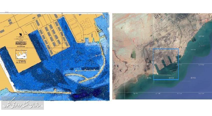
The berthing chart of Shahid Rajaee Port, the largest commercial port of Iran, which plays a major role in the country's commercial development, is produced by National Cartographic Center.
According to NCC report, Ms. Mojtahedi, Deputy of Hydrography and Tidal Affairs Department of NCC, announced the production of the first berthing chart of Shahid Rajaei Port in Iran.
She said: “With the production of this chart, the coastal and berthing usage bands of this port are ready to be employed by the sailors. Shahid Rajaei Port is the largest commercial Port of Iran, which plays a major role in the country's commercial development; therefore, the production and updating of the nautical charts of this port are of significant importance for NCC.
Due to the importance of this issue, coastal, approach, and port usage band charts are produced for the users so far, and with the production of berthing chart of this port, all navigational charts of Shahid Rajaei Port are available according to the standards of the International Hydrographic Organization (IHO)”.
She also added: “National Cartographic Center of Iran has nearly four decades of experience in Hydrography and has produced hundreds of nautical charts from the Persian Gulf, the Sea of Oman, and the Caspian Sea since 1988. Due to its sovereign role in the production and dissemination of spatial data, NCC is responsible for the production of nautical charts in accordance with international IHO standards, which have played a major role in ensuring maritime safety”.
Mojtahedi continued: “Berthing chart of Shahid Rajaei Port is the largest scale chart of this important commercial port, which is used to help accurate navigation, and therefore has the highest accuracy, especially in the field of coastal features
It is necessary to explain that Hydrography and Tidal Affairs Department of NCC has provided accurate information on coastal features and this information has been used in preparing the new chart. Berthing chart of Shahid Rajaei Port will be published internationally by National Hydrographic Committee in the near future, and it will be ready to be employed by the sailors after the final controls”.
Special Economic Zone of Shahid Rajaee port is located 23 km away from the west of Bandar Abbas, north of Qeshm Island and the Strait of Hormuz, and is responsible for almost half of Iran's trade by having maritime relations and exchanging goods with 80 famous international harbors.


comment