

Another service from National Cartographic Center of Iran:
Ease of Quick Access to Digital Version of NCC Products
In another service provided by National Cartographic Center of Iran, ease of quick access to the digital version of NCC Products is enabled for the applicants.

21۱ March, the International Day of Nowruz
Nowruz, Celebration of Spring Arrival and New Year in IRAN
March 21۱ is the first day of spring. But for about 300 million people around the world, it’s the beginning of a new year, too. Nowruz, which means “new day”, is a holiday marking the arrival of spring and the first day of the year in Iran, whose solar calendar begins with the vernal equinox.
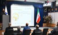
Director General of National Cartographic Center of IRAN, at the opening ceremony of the 26th National Conference and Exhibition
To Build Synergy Among Experts in Mapping and Spatial Data and to Provide its Services to Users, Including Knowledge-Based companies, Universities are of Conferecne Important Goals
Dr. Ali Javidaneh, Director General of National Cartographic Center of IRAN, at the opening ceremony of the 26th National Conference and Exhibition of Surveying and Spatial Information announced that build Synergy Among Experts in Mapping and Spatial Data and to Provide its Services to Users, Including Knowledge-Based companies, Universities are of Conference Important Goals

Message from Dr. Mirkazemi, Vice President and Head of Plan and Budget Organization of the Islamic Republic of Iran at the Openi
Plan and Budget Organization and National Cartographic Center with Heavy Responsibility of Policy-making, Leadership, Coordination, Budgeting and Management For All Fields of Surveying Engineering in Iran
Dr. Mirkazemi, Vice President and Head of Plan and Budget Organization of the Islamic Republic of Iran, in a message on the occasion of the 26th National Conference and Exhibition of Surveying Engineering and Spatial Information said: “Plan and Budget Organization of the Islamic Republic of Iran and National Cartographic Center of Iran have a heavy responsibility of policy-making, leadership, coordination, budgeting and management of all fields of surveying engineering in the country by defining the vision of the field”.
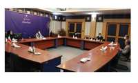
With the presence of the Ministry of Agriculture, the Environmental Protection Organization and General Department of GIS and SD
Holding Second Specialized Meeting on Equipping Country's Soils with Spatial Technologies
The second specialized meeting in line with the decision of the Cabinet which was reviewed and approved at the proposal of the Ministry of Agriculture and in cooperation with the Environmental Protection Organization, was held at National Cartographic Center of IRAN.
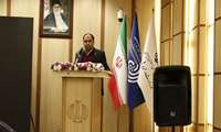
At the Closing Ceremony of the Fifth International Conference on Persian Gulf Oceanography, Dr. Javidaneh announces:
Country Development Programs Require More Attention to Seas and Coasts / Conservation and Sustainable Use of Resources Requires Full knowledge
Dr. Javidaneh, the Acting Director General of the National Cartographic Center of IRAN, at the closing ceremony of the 5th International Persian Gulf Oceanography Conference said: "The country's development plans require more attention to the country's seas and coasts/ T Conservation and Sustainable Use of Resources requires a full understanding of it"
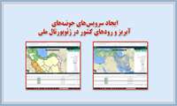
Cartography and National Atlases Department of NCC announces:
Country Rivers and Catchment Basins Services Presentation in National Geoportal
Presentation of the country's rivers and catchment basins services in the National Geoportal were carried out by the Cartography and National Atlases Department of the National Cartographic Center of IRAN.

With the presence of National Cartographic Center Representative at the 32nd meeting of the ECO Regional Planning Committee (RPC
International Training Course for Economic Cooperation Organization (ECO) Members / Hosting Third ECO Surveying Organizations Heads Meeting by NCC
With the presence of the representative of NCC in the 32nd meeting of the ECO Regional Planning Committee (RPC), holding an international training course for ECO members and reviewing the hosting of the third meeting of the heads of surveying organizations of the Economic Cooperation Organization (ECO) was discussed.

The Secretariat of the 26th National Conference on Surveying Engineering and Spatial Information announces:
Obtaining Articles Display Permission in Islamic World Science Citation Center (ISC)
Secretariat of the 26th National Conference on Surveying Engineering and Spatial Information (Geomatics 1۱400) announced that following the Scientific Association of Surveying and Geomatics Engineering of Iran, the conference was licensed by the Commission of Scientific Associations of the Ministry of Science and also this conference has succeeded in obtaining permission to display articles in the Islamic World Science Citation Center (ISC).
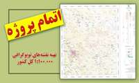
Cartography and National Atlases Department of NCC announces:
One Hundred Thousand Scale Topographic Maps Project Completes
The project of preparing the country coverage maps in scales of 1۱: 1۱00000 was completed by the cartography and national atlases department in the national cartographic center of IRAN.