
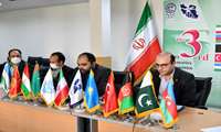
At the 3rd ECO Geomatics Committee Meeting, Acting Director General of NCC states:
IRAN Self-Sufficiency in Spatial Information Field/ NCC Ready to Export Innovative Technical and Engineering Services of Spatial Information Knowledge Abroad
At the 3rd ECO Geomatics Committee Meeting, Dr. Ali Javidaneh, Acting Director General of NCC, stated that we are self-sufficient in meeting our scientific needs in the field of spatial information and are ready to export innovative technical and engineering services of spatial information knowledge abroad

Providing distance services for NCC users:
Twenty Percent Growth in Sending Products to NCC Applicants
In order to provide distance services for NCC users, during April to September 2021۱, sending orders to the applicants of NCC products has increased by twenty percent compared to the same period last year.
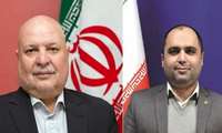
Dr. Seyed Massoud Mirkazemi, Vice President and Head of Plan and Budget Organization appoints:
Dr. Ali Javidaneh, Acting Director General of National Cartographic Center
By order of Dr. Seyed Massoud Mirkazemi, Vice President and Head of the Plan and Budget Organization, Acting Director General of National Cartographic Center was appointed.
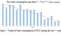
With the proper management and optimization at National Cartographic Center:
Water Consumption Reaches Lowest Level in Last Decades
NCC has undergone a process of reducing water consumption by optimizing and managing techniques and the index confirms that.
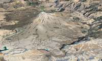
Department of Geodesy and Land Surveying of NCC announces:
Gravitational Acceleration Measurement of Damavand Peak Permanent Points
National Cartographic Center of Iran starts to measure the gravitational acceleration of permanent points around Damavand peak
General Department of Geodesy and Land Surveying announces:
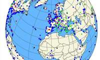
Latest International Terrestrial Reference Framework ITRF 2020 Becomes Operational
Since the establishment of the IERS International Service, which produces earth rotation parameters and reference frameworks, 1۱3 copies of ITRF have been published from ITRF88 to ITRF201۱4. A network of stations that have their position and speed precisely defined the reference framework, that is a practical realization of the reference system,.
Congratulatory Message of Dr. Jafarzadeh Imanabadi, Director General of NCC on Abu Rayhan Al-Biruni’s Birth Anniversary, Surveying Engineering Day
Dr. Jafarzadeh Imanabadi, the Director General of NCC conveyed a congratulatory message to the presidents of the International Associations on the birth anniversary of Abu Rayhan Al-Biruni, the great Iranian scholar and polymath.
Hydrography and tidal affaires department of NCC announces:
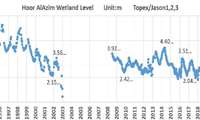
Iran Largest Wetland Water Decline/Bitter Days for Hur al-Azim
The Comparison of the water level of Hur al-Azim wetland in June 2021۱ with the same time last year (June 2020) using satellite data demonstrates that the water level has decreased by 50 cm

Dr. Ali Madad, Manager of the General Department of GIS and SDI:
Spatial Information Role in Coronavirus Pandemic Crisis Management
Dr. Ali Madad, Manager of the General Department of GIS and SDI of NCC expounds on the role of spatial information in coronavirus pandemic crisis management around the world
The Department of Hydrography and Tidal Affairs of NCC announces:
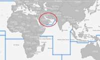
Iran's First Rank in International Production and Publication of Nautical Charts in Persian Gulf and Oman Sea
The Islamic Republic of Iran, with production and registration of 48 INT Charts, as well as the publication of 93 Electronic Navigational Charts (ENC) internationally from the ROPME sea area, including the Persian Gulf and the Sea of Oman, is the first among the countries of the region.


