

With the presence of the representative of NCC in the thirty-third meeting of ECO Regional Planning Committee, was proposed:
Holding International Training Course for ECO Member Countries in 2023/ Hosting the third Meeting of ECO Heads of Surveying and Mapping Organizations and the fourth ECO Geomatics Committee by National Cartographic Center of Iran
With the presence of the representative of National Cartographic Center of Iran, in the thirty-third meeting of ECO Regional Planning Committee (RPC), holding an international training course for ECO member countries in 2023, hosting the third meeting of ECO Heads of Surveying and Mapping Organizations and the fourth ECO Geomatics Committee by National Cartographic Center of Iran were proposed.

After the request of the Ministry of Foreign Affairs from NCC:
Membership of NCC in Human Resources and Sustainable Development Committee of Economic Cooperation Organization (ECO)
After the request of the Ministry of Foreign Affairs of NCC to become a member of the human resources and sustainable development committee of the Economic Cooperation Organization (ECO), with the presence of the organization's representative in the meeting of this committee in the 33rd meeting of the ECO Regional Planning Council, NCC was officially chosen as the member in this committee.

On the occasion of the 30th anniversary of the expansion of ECO member countries, after the official invitation of ECO secretari
Presence of Director General of NCC at Official Ceremony of 30th Anniversary of Economic Cooperation Organization (ECO) Enlargement
On the occasion of the 30th anniversary of the enlargement of ECO member countries, after the official invitation of the ECO Secretary General, the Director General of NCC participated in the official ceremony of the 30th anniversary of the expansion of ECO member countries at the Ministry of Foreign Affairs.

After the selection of Director General of the National Cartographic Center of Iran, as the representative of the Islamic Republ
Dispatching Delegation of Islamic Republic of Iran Headed by NCC in High-level Consultative Meeting on Risk Data Monitoring and Disaster Information Management in Turkey
After the selection of Director General of the National Cartographic Center of Iran, as the representative of the Islamic Republic of Iran in the meeting of the APDIM Governing Council, dispatching the delegation of the Islamic Republic of Iran headed by NCC, they participated and gave speeches in the high-level consultative meeting on risk data monitoring and disaster information management which was held in Istanbul, Turkey.
Subsequent to choosing the Director General of NCC as the representative of the Islamic Republic of Iran in APDIM:
Presence of Director General of NCC as Official Representative of Islamic Republic of Iran in APDIM’s Seventh Meeting of Governing Council in Turkey
After the election of the Director General of NCC as the representative of the Islamic Republic of Iran in the Governing Council of the Asian and Pacific Centre for the Development of Disaster Information Management (APDIM), Ali Javidaneh as the official representative of the country participated in the APDIM’s Seventh Meeting of the Governing Council in Istanbul, Turkey and presented the official report of the country.

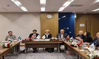
With the presence of the Director General of NCC in the Eleventh Plenary Meeting of UN-GGIM-AP, an important international achie
Improving Position of NCC as Iran's Representative in UN-GGIM-AP Executive Board / NCC Takes Head of Spatial and Statistical Data Integration Working Group in UN-GGIM-AP
With the presence of the Director General of NCC in the Eleventh Plenary Meeting of UN-GGIM-AP, NCC on behalf of the Islamic Republic of Iran and the only West Asian country in the UN-GGIM-AP Executive Board was elected as the main member after voting, also in another important international achievement for the country, NCC became the head of the Spatial and Statistical Data Integration Working Group

In line with the implementation of the international memorandum of understanding between the State Committee of Land Managemen
Presence of Director General and Senior Managers of NCC to Assess Needs and Evaluate Technical Priorities of State Committee for Land Management and Geodesy of Republic of Tajikistan in Mapping and Spatial Information Field
In line with the implementation of the international memorandum of understanding concluded between the State Committee of Land Management and Geodesy of the Republic of Tajikistan and NCC of the Islamic Republic of Iran, a delegation consisting of the director general and senior managers of NCC for the purpose of assessing the needs and evaluating the technical priorities of the State Committee of Land Management and Geodesy of the Republic Tajikistan participated in the field of spatial information in the central building of the State Committee for Land Management and Geodesy of the Republic of Tajikistan in Dushanbe.

After hours of visits and intensive meetings between the State Committee of Land Management and Geodesy of the Republic of Tajik
Signing the Protocol of the Joint Meeting of NCC of Iran with the State Committee of Land Management and Geodesy of the Republic of Tajikistan to export Technical and Engineering Services
After hours of visits and intensive meetings between the State Committee of Land Management and Geodesy of the Republic of Tajikistan and the head and senior managers of NCC, the protocol of the joint meeting of NCC of Iran with the State Committee of Land Management and Geodesy of the Republic of Tajikistan in order to export technical and engineering services was signed.
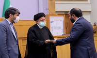
For the first time, an important achievement and honor on the eve of the 70th years of the establishment of NCC:
Obtaining Top Performance Evaluation Rank in Seventeenth Festival of Shahid Rajaei, 2022
For the first time, on the eve of the 70th year of the establishment of National Cartographic Center of Iran; this organization managed to get the top performance evaluation rank in the 17th Festival of Shahid Rajaei, 2022.

Message from Dr. Mirkazemi, Vice President and Head of Plan and Budget Organization of the Islamic Republic of Iran at the Openi
Plan and Budget Organization and National Cartographic Center Have Heavy Responsibility of Policy-making, Leadership, Coordination, Budgeting and Management For All Fields of Surveying Engineering in Iran
Dr. Mirkazemi, Vice President and Head of Plan and Budget Organization of the Islamic Republic of Iran, in a message on the occasion of the 26th National Conference and Exhibition of Surveying Engineering and Spatial Information said: “Plan and Budget Organization of the Islamic Republic of Iran and National Cartographic Center of Iran have a heavy responsibility of policy-making, leadership, coordination, budgeting and management of all fields of surveying engineering in the country by defining the vision of the field”.


