
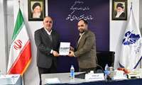
Following the interactions between the International Cooperation Office of NCC with the Ministry of Foreign Affairs:
UN-ESCAP Director of Strategy and Program Management Division Meets NCC Director General

After the invitation of the Federal Service for State Registration, Cadastre and Cartography of Russia to NCC of Iran:
NCC Director General's Speech at specialized Panel of KazanForum, Russia

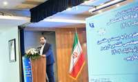
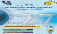
National Cartographic Center of Iran holds:
The 27th National Conference and Exhibition on Geomatics Engineering (Geomatics 2023)
National Cartographic Center of Iran holds the 27th National Conference on Geomatics Engineering (Geomatics 2023) on 1-2 May 2023 and hosts the interested and activists in this field; the conference venue is onsite.

following the invitation of the director of APDIM from NCC:
Presence of the Representative of National Cartographic Center in International Meeting of the United Nations Sustainable Development Cooperation Framework (UNSDCF)
following the invitation of the director of APDIM from NCC, the representative of NCC participated in the international meeting of the United Nations Sustainable Development Cooperation Framework (UNSDCF)

After the election of National Cartographic Center of Iran (NCC) as the sole representative of Iran in APDIM:
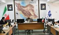
Meeting of Asian and Pacific Centre for the Development of Disaster Information Management Director with NCC Director General
After the election of National Cartographic Center of Iran (NCC) as the sole representative of Iran in the Asian and Pacific Centre for the Development of Disaster Information Management (APDIM), Mrs. Letizia Rossano, the director of the Asian and Pacific Centre for the Development of Disaster Information Management (APDIM), met with the director general of NCC.
In order to issue the technical engineering services of National Cartographic Center (NCC):
Holding the First Webinar Between Ministry of Agriculture of Republic of Turkmenistan And NCC
After the election of NCC as the sole representative of Iran in APDIM:
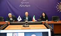
First Meeting on Developing National Capacities and Expanding International Cooperation with the Asian and Pacific Centre for the Development of Disaster Information Management (APDIM) in National Cartographic Center of Iran
After the election of National Cartographic Center of Iran (NCC) as the sole representative of Iran in the Asian and Pacific Centre for the Development of Disaster Information Management (APDIM), the first meeting on Developing National Capacities and Expanding International Cooperation with APDIM was held in NCC.
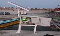
It was carried out by National Cartographic Center of Iran:
Installing Sea-Level Monitoring Station in Gorgan Bay Area
The sea-level gauge station was successfully located and installed in Gorgan Bay, Bandar Turkmen region by experts of Hydrography and Tidal Affairs Department of National Cartographic Center of Iran in January 2023.


