
At the Closing Ceremony of the Fifth International Conference on Persian Gulf Oceanography, Dr. Javidaneh announces:
Country Development Programs Require More Attention to Seas and Coasts / Conservation and Sustainable Use of Resources Requires Full knowledge
Dr. Javidaneh, the Acting Director General of the National Cartographic Center of IRAN, at the closing ceremony of the 5th International Persian Gulf Oceanography Conference said: "The country's development plans require more attention to the country's seas and coasts/ T Conservation and Sustainable Use of Resources requires a full understanding of it"
Cartography and National Atlases Department of NCC announces:
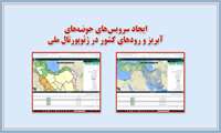
Country Rivers and Catchment Basins Services Presentation in National Geoportal
Presentation of the country's rivers and catchment basins services in the National Geoportal were carried out by the Cartography and National Atlases Department of the National Cartographic Center of IRAN.

With the presence of National Cartographic Center Representative at the 32nd meeting of the ECO Regional Planning Committee (RPC
International Training Course for Economic Cooperation Organization (ECO) Members / Hosting Third ECO Surveying Organizations Heads Meeting by NCC
With the presence of the representative of NCC in the 32nd meeting of the ECO Regional Planning Committee (RPC), holding an international training course for ECO members and reviewing the hosting of the third meeting of the heads of surveying organizations of the Economic Cooperation Organization (ECO) was discussed.

The Secretariat of the 26th National Conference on Surveying Engineering and Spatial Information announces:
Obtaining Articles Display Permission in Islamic World Science Citation Center (ISC)
Secretariat of the 26th National Conference on Surveying Engineering and Spatial Information (Geomatics 1۱400) announced that following the Scientific Association of Surveying and Geomatics Engineering of Iran, the conference was licensed by the Commission of Scientific Associations of the Ministry of Science and also this conference has succeeded in obtaining permission to display articles in the Islamic World Science Citation Center (ISC).
Cartography and National Atlases Department of NCC announces:
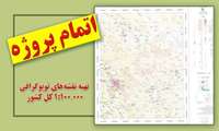
One Hundred Thousand Scale Topographic Maps Project Completes
The project of preparing the country coverage maps in scales of 1۱: 1۱00000 was completed by the cartography and national atlases department in the national cartographic center of IRAN.
NCC announces:
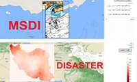
Crisis Management National Subportal Development/ National Marine Spatial Data Infrastructure Subportal Launch
After launching the national spatial data infrastructure, the National Cartographic Center of IRAN developed the national crisis management sub-portal and launched the National Marine Spatial Data Sub-Portal.
Dr. Ali Javidaneh's Congratulatory Message On New Year Beginning
In a message to the Presidents of the International Surveying Associations, Dr. Ali Javidaneh, Acting Director General of the National Cartographic Center of IRAN, congratulated the birth of Jesus Christ, the Messenger of Peace and Friendship, as well as the beginning of the New Year (2022).
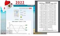
Hydrography and Tidal Affairs Department announces:
Country Southern Coasts Tidal Forecast Through Sea Level Monitoring Website in 2022
Tidal forecasts for 53 country’s southern coast stations in 2022 were made available to researchers and marine activists at the sea level monitoring website.
The Hydrography and Tidal Affairs Department announces:
International Publication of 2 New Kangan Port Navigational Charts
Announcing the international publication of Kangan port charts and Kangan port access to Deir, the Hydrographic and Tidal Affairs Department of the National Cartographic Center of IRAN announced the possibility of sailors using these charts for safe navigation in the country's waters. With the publication of these charts, the number of charts that the NCC has internationally published reaches 65.
National Cartographic Center of IRAN (NCC) is holding the largest national event in the surveying and spatial information’s fiel
26th National Conference and Exhibition of Surveying Engineering and Spatial Information; Geomatics 1۱400
The National Cartographic Center of IRAN (NCC) is holding the 26th National Conference on Surveying Engineering and Spatial Information, which is the largest national event in surveying and spatial information, with the motto "Spatial information; the country's economic development Infrastructure"


