
General Department of GIS and SDI announces:
NCC Geoportal Establishment for 27 provinces
Another golden leaf was registered in the record of the General Department of GIS and SDI of National Cartographic Center (NCC) with continuous pursuits and efforts of the experts of the department.
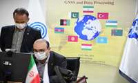
In the 3rd ECO Geomatics Committee Training Course, National Cartographic Center of Iran proposes:
NCC to Establish ECO GNSS Permanent Network and ECO Reference Framework (ECO-RF) for ECO member States
In the 3rd ECO Geomatics Committee Training Course, National Cartographic Center of Iran proposed the establishment of ECO GNSS Permanent Network and ECO Reference Framework (ECO-RF) for ECO member states

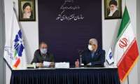
Eng. Ghanbarzadeh, General Manager of Director's office, Public and International Relations of NCC, announces:
National Cartographic Center Hosting 3rd ECO Geomatics Committee Training Course on GNSS and Data Processing
Eng. Ghanbarzadeh, General Manager of Director's office, Public and International Relations of NCC, announces: “National Cartographic Center of Iran is hosting the Virtual Training Course on “Reference Frames and Global Navigation Satellite System (GNSS) and Data Processing.”
.jpg)
National Cartographic Center attends UN-GGIM-AP Executive Board Meeting:
IRAN Retention as UN-GGIM-AP EB Member
UN-GGIM-AP Executive Board Meeting was held with the participation of the National Cartographic Center of the Islamic Republic of Iran ,and the membership of NCC was retained in UN-GGIM-AP Executive Board for another year.
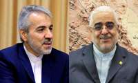
Dr. Nobakht's message of appreciation to Dr. Jafarzadeh Imanabadi on:
National Cartographic Center First Rank in E-Government Development
After achieving the first rank of the National Cartographic Center of IRAN (NCC) in the field of e-government development of Shahid Rajaee Festival and achieving the second rank of the sixth e-services evaluation period; Dr. Nobakht appreciated Dr. Jafarzadeh Imanabadi in a letter.
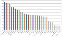
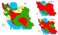
Department of GIS and SDI of NCC announces:
Participation Increase in National Geoportal
Department of Geospatial Information Systems and Spatial Data Infrastructure (GIS and SDI) of NCC announces the significant increase in Provincial National Geoportal establishment, and its performance growth over the past 3 months
e-Government
Energy Ministry Ready to Conclude MOU with NCC
According to the Technical Services Department of NCC, the Ministry of Energy is ready to cooperate and conclude a Memorandum of Understanding (MOU) with NCC

National Cartographic Center Defence of Persian Gulf Name at United Nations
National Cartographic Center of IRAN (NCC) strongly defended the name of the Persian Gulf in a meeting at the United Nations Group of Experts on Geographical Names (UNGEGN), virtually held in New York from May 3-7, 2021۱.
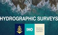
The Hydrography and Tidal Affairs Department announces:
National Cartographic Center Effective Presence in International Hydrographic Organization Working Group
By membership of the representative of NCC in the Hydrography working group of IHO (IHO_ HSWG), the Islamic Republic of Iran will have a more effective presence in IHO


