
Hydrography and Tidal Affairs Department announces:
Over 64000 Electronic Navigational Charts Sales in 2020
Electronic Navigational Charts of the country's waters produced by the National Cartographic Center of Iran have been replaced with foreign charts which play a major role in ensuring maritime safety based on global requirements.
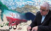
Dr. Jafarzadeh Imanabadi, the Director General of NCC on the national day of the Persian Gulf:
Persian Gulf, Symbol of Ancient Iranian History, Culture, Civilization; Vital Artery of Economic Exchange in Middle East
Dr. Jafarzadeh Imanabadi, the Director General of NCC conveyed a message to the presidents of the International Associations on the national day of the Persian Gulf.

Congratulatory message of Dr. Jafarzadeh Imanabadi, Director General of NCC on Earth Day
Dr. Jafarzadeh Imanabadi, Director General of National Cartographic Center of Iran (NCC) conveys a congratulatory message to the presidents of the International Surveying Associations on Earth Day
Message of the Director General of NCC, Dr. Jafarzadeh Imanabadi to the Senior National and Military Officials on the Occasion o
Dr. Jafarzadeh Imanabadi, the Director General of NCC conveys a congratulatory message to the senior national and military officials on the occasion of the beginning of the Persian New Year(Nowruz)
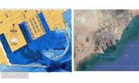
Hydrography and Tidal Affairs Department of National Cartographic Center of Iran announces:
Shahid Rajaee Port Berthing Chart Production
The berthing chart of Shahid Rajaee Port, the largest commercial port of Iran, which plays a major role in the country's commercial development, is produced by National Cartographic Center.
The Standardization Group of NCC announced:
The 8th volume of the National Grid Standard is published by NCC
The 8th volume of the National Grid Standard, from the series of Unified Surveying Instructions is published by National Cartographic Center of Iran (NCC)

Hydrography and Tidal Affairs Department announced:
International publishing of Astara port navigation chart
With international publishing of the chart of access to Astara port, it becomes possible for sailors to use this chart for safe navigation in the country's waters. It should be noted that with publishing of this chart, the total number of charts published by National Cartographic Center of Iran (NCC) at the international level reached 61 marine navigation charts, 13 of which belong to the Caspian Sea and the rest belong to the Persian Gulf and the Sea of Oman.

Following the inquiries and follow-ups of National Cartographic Center of Iran:
The approved vocabulary collection in the field of Surveying Engineering was announced by the Academy of Persian Language and Literature
The Academy of Persian Language and Literature announced the approved vocabulary collection in the field of Surveying Engineering.

At the meeting between the CEO of the National Post Company of the I. R. of Iran and the Director General of National Cartograph
Improving the NCC electronic services quality level to present to the community
In a joint meeting among Ramadan Ali Sobhanifar, Deputy Minister of Communications and Information Technology & CEO of the National Post Company of the I. R. of Iran and Mehdi Maghsoudi, General Manager of Tehran Province Post and Dr. Jafarzadeh Imanabadi, Director General of National Cartographic Center (NCC), the specialized and practical dimensions of improving the quality level of the NCC’s electronic services to provide to the community were reviewed.


